A new initiative called the Barrier-Free Map seeks to ensure that everyone is able to smoothly access all the world-class parks and cultural institutions available in Ueno. Created by Implementation Committee for New Concept “Ueno, a Global Capital of Culture”, the map indicates recommended routes from train stations to sites around the neighborhood, with detailed information on road conditions and steep slopes to help wheelchair-bound visitors and others plan their trip in advance. We caught up with the team involved in the map’s development as they performed a “route check,” a meticulous and important task that is breaking down barriers in Ueno.
A guide for wheelchair users, by wheelchair users
The Ueno Barrier-Free Map is an indispensable resource that aims to provide stress-free access to wheelchair users, stroller-toting parents, and everyone else who visits the Ueno area. In addition to barrier-free facilities — including elevators, wheelchair-friendly parking lots, and accessible restrooms — the map also highlights the most convenient routes from train stations to each of the many cultural facilities and other destinations in Ueno. For even more convenience, a dedicated team has been working to annotate the user-friendly map with notes on staircases, bumps, unpaved stretches of road, and prohibitively steep inclines, to create a comprehensive guide to all the routes that can be traversed by wheelchair.
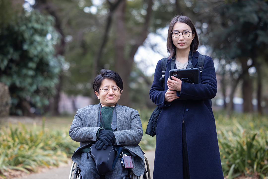
Mirairo Inc.’s Fujita (left) and Mizuno (right).
The Ueno
Barrier-Free Map aims to serve as a practicable source of information created
by wheelchair users, for wheelchair users. That’s why the map developers have
enlisted the help of the universal design consultants at Mirairo Inc.
Mirairo is
on a mission to transform both environments and minds, leveraging the
experience and knowhow of their physically disabled consultants to create a
more conducive and inclusive society for all.
The Ueno Barrier-Free Map project is a
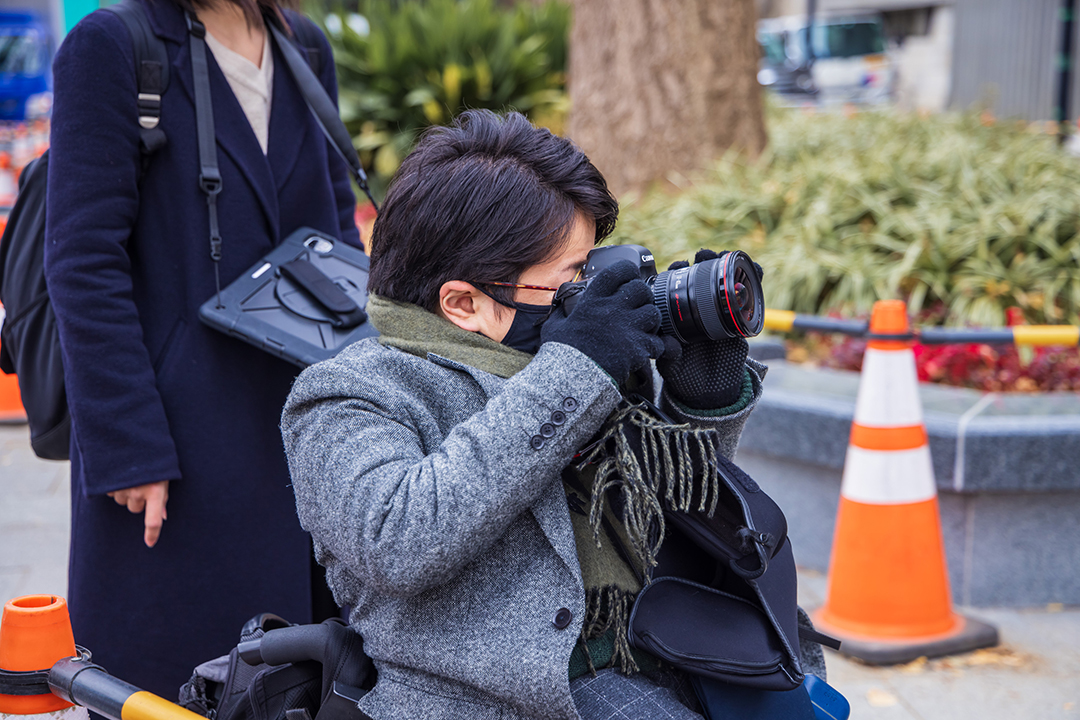
team effort between designer Takahisa Fujita, a wheelchair user who identifies
routes and real-life accessibility conditions, and director Sayumi Mizuno, who
applies information relayed by Fujita to the finished map.
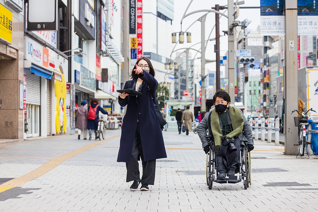
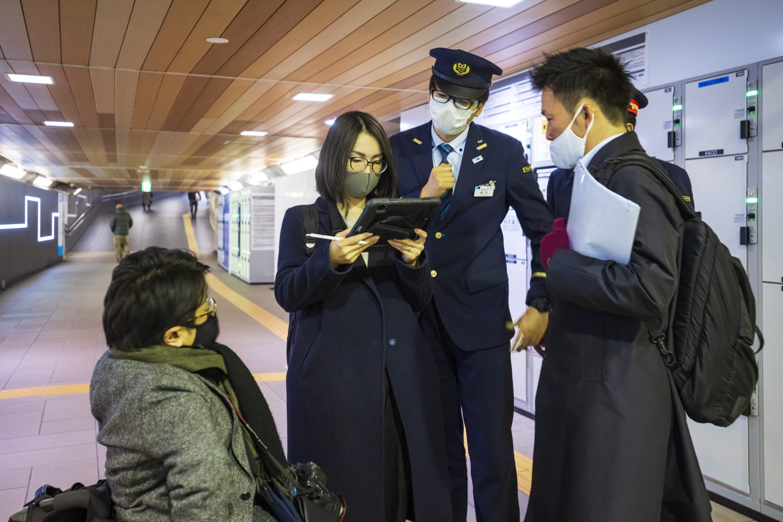
To better understand how they go about collecting all the data needed to update their barrier-free map, we accompanied the duo from Ueno-Hirokoji Station on the Tokyo Metro Ginza Line to the Tokyo Bunka Kaikan as they surveyed the pedestrian walkways around JR Ueno Station and checked in on the Tokyo National Museum’s garden.
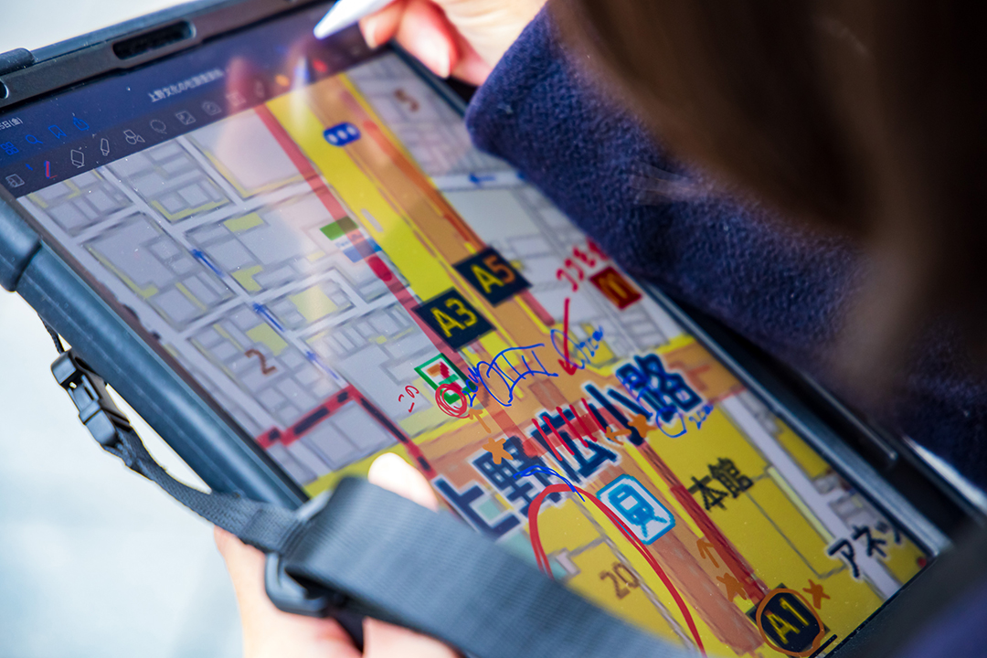
When we’re paying closer attention, all the bumps, slopes, and irregularities in the street jump out.Mizuno takes notes on a tablet in consultation with Fujita.
Searching for the shortest route to a destination
“The
Barrier-Free Map is an important source of information, such as the shortest
and flattest route to a destination for wheelchair users. When identifying
these routes, we scrutinize the steepness of streets, identify obstructions,
and note the length of slopes, as well as the locations and operating hours of
elevators. There are many slopes and bumpy grade differences that people tend
to overlook when walking. But for people in wheelchairs, these inconsistencies
become obstructions that are very tiring to clear,” said Fujita.
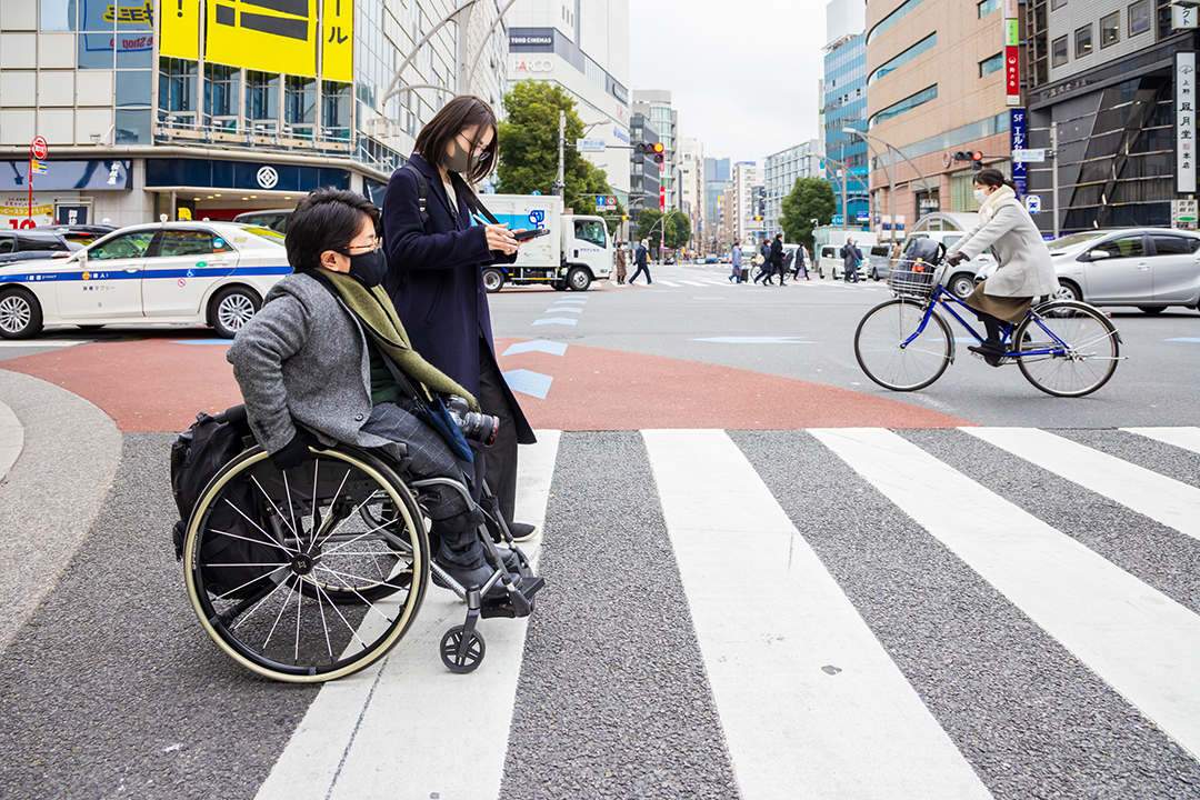
Fujita
pointed out pedestrian crosswalks in particular. There is always a height
differential where the road meets the sidewalk, not to mention frequent
manholes and sharp inclines for rainwater runoff. When accompanying Fujita, we
saw the profusion of obstacles on the streets come into stark relief.
The team travelled back and forth across the same pedestrian crossing, taking photos and collecting precise data to pinpoint the absolute best possible route through the intersection. They explained that the photos are also a very important tool.
Pedestrian crosswalks are a critical checkpoint. The team thoroughly investigates the best angle of attack and notes potential issues.Ueno’s Barrier-Free Map features copious photographs of each route. Fujita snapped photos of each source of concern.
“Your
perspective is different when you’re sitting in a wheelchair. Someone who’s
standing might have no problem seeing elevators, train station ticket gates,
and signs showing the entrances to museums. But these things might not be
visible from a wheelchair. That’s why we make a point of using photos taken
from the eye level of a wheelchair-user. We’re very careful to ensure that
people will be able to arrive at their destination without getting lost,” said
Mizuno.
The need for such photos was underscored
by Ueno-Hirokoji Station on the Tokyo Metro Ginza Line, the oldest line in the
sprawling Tokyo Metro system. Although Tokyo Metro has been retrofitting their
stations for greater accessibility, the smoothest route is also often the most
roundabout, requiring a long detour. By having this information in advance,
travelers can save significant time and energy.
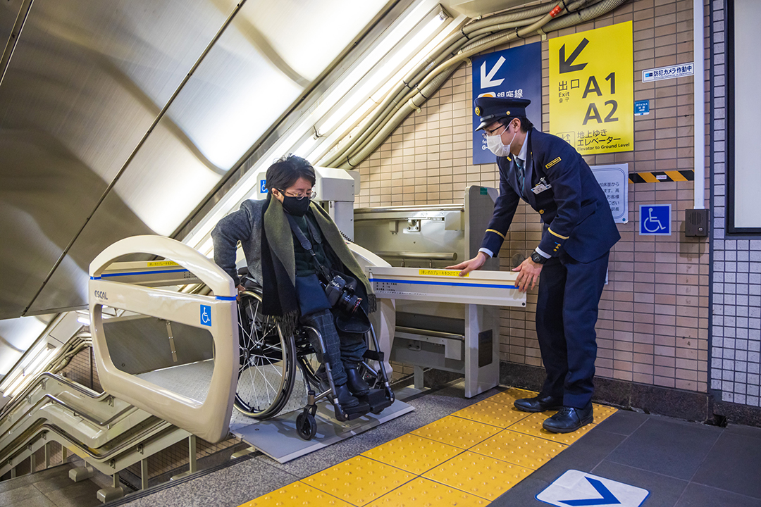
For example, an elevator at Ueno-Hirokoji Station was still
under construction when we visited. The only way to reach the Asakusa-bound
platform was to travel over the regular staircase in a wheelchair lift called
the ESCAL.
Fujita strapped in for the survey’s sake, traveling up and down to check the ceiling clearance and the number of station staff needed to operate the lift. By interviewing a station attendant, he and Mizuno also discovered an alternative route to access the Asakusa-bound platform without using the ESCAL. It turns out that wheelchair users could simply disembark at the next train station, which provides a straight shot to the opposing platform. Although a bit time-consuming, the route saves the hassle of using the ESCAL.
Universal design for all
After
completing the 30-minute survey of the station, the team set off for the day’s
final destination: the Tokyo National Museum. Specifically, Fujita and Mizuno
were on a mission to check out the accessibility of the Museum Garden to the
north of the Honkan(Japanese Gallery). Although the
garden is included in the price of admission to the museum, it remains
something of a well-kept secret. On the day they visited, the garden was closed
for construction. Fujita thoroughly checked the width and angle of incline of
the access routes, and shared his observations with the museum staff member who
guided us.
As Fujita explained: “Knowing the
smoothest routes to your destination gives you the confidence to be more
proactive and get out of the house more. But this sort of detailed information
is lacking in conventional maps. By actually traveling the routes ourselves,
we’re able to improve maps with helpful information that can actually be used.
Plus, we’re able to directly inform the museums and train stations about our
findings, which helps them improve their accessibility. It’s a win-win. If
universal design becomes more widespread, the world will become a more
convenient place for everyone. It will make life easier not only wheelchair
users like myself, but people with baby strollers, people with chronic
illnesses, and even people who don’t have disabilities. I plan to keep working
to make sure this information becomes more readily available to everyone who
can use it.”